![]()
![]()
Home ![]() Pre Katrina Home
Pre Katrina Home ![]() Orleans Parish
Orleans Parish ![]() Central City/ Garden District
Central City/ Garden District ![]() St. Thomas
Development
St. Thomas
Development
This information is pre-Katrina. For current data about New Orleans and its neighborhoods, visit our homepage. |
St. Thomas Development Neighborhood
“As of the 2000 Census there were still some 2,957 residents in the census tracts associated with the St. Thomas Housing Development. But as of August 30, 2001, 1393 units (of the 1,429 that were counted in the 2000 census) were demolished. Five buildings were saved for historical purposes. The data about this neighborhood, therefore, are no longer accurate. Most of the residents have been moved to the surrounding neighborhood or to New Orleans East.”[Read more in the Neighborhood Snapshot]
Street map with links
to nearby neighborhoods: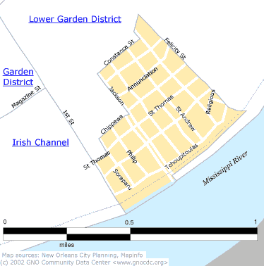
| [ Census tract and zip code boundary maps ] |
Census 2000 Data Tables: People & Household Characteristics, Housing & Housing Costs, Income & Poverty, Transportation, Employment, Educational Attainment, Immigration & Language, Disabilities, Neighborhood Characteristics
Home ![]() Pre Katrina Home
Pre Katrina Home ![]() Orleans Parish
Orleans Parish ![]() Central City/ Garden District
Central City/ Garden District ![]() St. Thomas
Development
St. Thomas
Development
![]()
|
The Community Data Center website is a product of Greater New Orleans Nonprofit Knowledge Works. Copyright © 2000-2. All Rights Reserved. Last modified: April 23, 2002 |