![]()
![]()
Home ![]() Pre Katrina Home
Pre Katrina Home ![]() Orleans Parish
Orleans Parish ![]() Algiers District
Algiers District ![]() U.S.
Naval Support Area
U.S.
Naval Support Area
This information is pre-Katrina. For current data about New Orleans and its neighborhoods, visit our homepage. |
U.S. Naval Support Area Neighborhood
“The Naval Support Area neighborhood is named after the largest military installation in the New Orleans area, the Naval Support Activity. This Activity facility comprises about half of the neighborhood, with civilian residential areas on either side. Many houses have the beauty of greenspace before them as they align the levee. People who live in military housing (both singles in group quarters and families) are included in Census data about this neighborhood – something to keep in mind as you analyze the data.” [Read more in the Neighborhood Snapshot]
Street map with links
to nearby neighborhoods: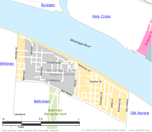
| [ Census tract and zip code boundary maps ] |
Census 2000 Data Tables: People & Household Characteristics, Housing & Housing Costs, Income & Poverty, Transportation, Employment, Educational Attainment, Immigration & Language, Disabilities, Neighborhood Characteristics
Home ![]() Pre Katrina Home
Pre Katrina Home ![]() Orleans Parish
Orleans Parish ![]() Algiers District
Algiers District ![]() U.S.
Naval Support Area
U.S.
Naval Support Area
![]()
|
The Community Data Center website is a product of Greater New Orleans Nonprofit Knowledge Works. Copyright © 2000-2. All Rights Reserved. Last modified: April 23, 2002 |