![]()
![]()
Home ![]() Pre Katrina Home
Pre Katrina Home ![]() Orleans Parish
Orleans Parish ![]() Bywater District
Bywater District
This information is pre-Katrina. |
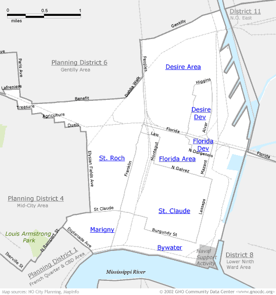
Bywater boundaries Note that these neighborhood boundaries (which must contain complete Census tracts) may differ slightly from boundaries commonly accepted by residents of the neighborhoods. A couple of key differences we know about... 1) The dividing street between St. Claude and Bywater is largely Burgundy (and partially St. Claude). 2) Franklin (rather than Press) divides the Marigny and Bywater. To learn more about the rationale behind these boundaries, read 'How is my neighborhood defined?' Also note that many of the neighborhoods in this district have strange shapes – the "stair-steps" along the St. Roch border and the horseshoe shape of Bywater. The neighborhood pages will have more detailed street maps, but it may be valuable to refer to a detailed paper map when examining these boundaries. |
|
About neighborhood boundaries: We've chosen the neighborhood boundaries on this web site to organize and present data. They may not match the boundaries of neighborhood associations, redevelopment corridors, commercial subdivisions, planning efforts, or historic districts. Learn more about how we chose these boundaries... |
|
Bywater District (Planning District 7)
Click on a neighborhood below to see 2000 Census data about it...

Home ![]() Pre Katrina Home
Pre Katrina Home ![]() Orleans Parish
Orleans Parish ![]() Bywater District
Bywater District
![]()
The Community Data Center website is a product of Greater New Orleans Nonprofit Knowledge Works. Copyright © 2000-2. All Rights Reserved. Last modified: October 4, 2002 |