![]()
![]()
Home ![]() Pre Katrina Home
Pre Katrina Home ![]() Orleans Parish
Orleans Parish ![]() French Quarter/CBD District
French Quarter/CBD District
This information is pre-Katrina. |
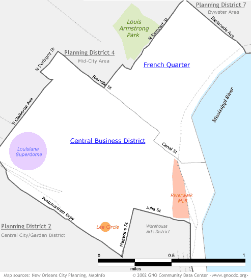
Where's the Warehouse Arts District?!? Since a lot of useful data for nonprofit planning and grantwriting comes from the Census, the Data Center has organized its neighborhood boundaries around Census tracts. Fortunately, NO City Planning had the same idea when they were setting up their planning districts. Except in the case of the Warehouse District, which is only part of a Census tract. If you're looking for data on the neighborhood that contains the Warehouse District, go to the Planning District 2 (Lower Garden District) page. |
|
About neighborhood boundaries: We've chosen the neighborhood boundaries on this web site to organize and present data. They may not match the boundaries of neighborhood associations, redevelopment corridors, commercial subdivisions, planning efforts, or historic districts. Learn more about how we chose these boundaries... |
|
French Quarter/ CBD District (Planning District 1)
Click on a neighborhood below to see 2000 Census data about it...
Home ![]() Pre Katrina Home
Pre Katrina Home ![]() Orleans Parish
Orleans Parish ![]() French Quarter/CBD District
French Quarter/CBD District
![]()
The Community Data Center website is a product of Greater New Orleans Nonprofit Knowledge Works. Copyright © 2000-2. All Rights Reserved. Last modified: October 4, 2002 |