![]()
![]()
Home ![]() Pre Katrina Home
Pre Katrina Home ![]() Orleans Parish
Orleans Parish ![]() New Orleans East Area
New Orleans East Area
This information is pre-Katrina. |
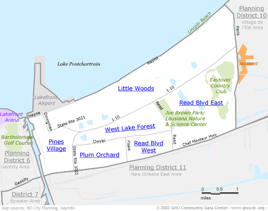
Where'd these neighborhood names come from? New Orleans East has relatively new neighborhoods, which also means that there's been less time for names and boundaries to establish themselves. Add to that a more rural density of housing, and you've got neighborhoods named after lakes, streets, and subdivisions that even residents may not have heard of. What is presented here is the NO City Planning neighborhood designations. It's a starting place for discussion, and a geography that aligns with Census tract boundaries so data can organized into these neighborhood groupings. New Orleans East also includes Planning Districts 10 and 1 1. |
|
About neighborhood boundaries: We've chosen the neighborhood boundaries on this web site to organize and present data. They may not match the boundaries of neighborhood associations, redevelopment corridors, commercial subdivisions, planning efforts, or historic districts. Learn more about how we chose these boundaries... |
|
New Orleans East Area (Planning District 9)
Click on a neighborhood below to see 2000 Census data about it...
Home ![]() Pre Katrina Home
Pre Katrina Home ![]() Orleans Parish
Orleans Parish ![]() New Orleans East Area
New Orleans East Area
![]()
The Community Data Center website is a product of Greater New Orleans Nonprofit Knowledge Works. Copyright © 2000-2. All Rights Reserved. Last modified: October 4, 2002 |